


SSC Foundation Eklavya - 1 Offline Cum Online Batch Lucknow Branch
27 July, 2026


Enter your Email ID and we'll send you a link to get back into your account.

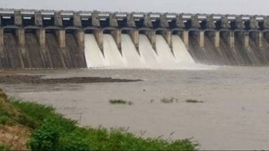

Shahpur Kandi Barrage/Dam Project
Fri 20 Feb, 2026
Context :
Shahpur Kandi Barrage/Dam Project :
Objectives:
Ravi River :
Indus Waters Treaty (1960):
| River Category | Rights of India | Rights of Pakistan |
| Eastern Rivers (Ravi, Beas, Sutlej) | Exclusive and unrestricted rights over waters; India can utilize 100% of water. | Pakistan has no rights over these waters (except very limited domestic use). |
| Western Rivers (Indus, Jhelum, Chenab) | Non-consumptive uses allowed: 1) Domestic use 2) Limited irrigation 3) Run-of-the-river hydropower projects (without storage). | Pakistan has primary rights. India is not permitted to divert waters or create large storage. |
27 July, 2026
22 July, 2026
20 July, 2026
26 May, 2026
08 May, 2026
20 April, 2026
01 April, 2026
01 April, 2026
16 March, 2026
15 March, 2026
