Revised Earthquake Design Code, 2025
 
  • Mobile Menu
HOME BUY MAGAZINEnew course icon
LOG IN SIGN UP

Sign-Up IcanDon't Have an Account?


SIGN UP


Login Icon

Have an Account?


LOG IN
 

or
By clicking on Register, you are agreeing to our Terms & Conditions.


or


Revised Earthquake Design Code, 2025

Tue 02 Dec, 2025

Reference:

  • The Bureau of Indian Standards (BIS) has released the updated seismic zoning map under the Revised Earthquake Design Code, 2025 (IS 1893:2025).

Key Points:

  • The revision is primarily based on modern scientific studies and the Probabilistic Seismic Hazard Assessment (PSHA) methodology.
  • The new seismic map introduces Zone 6, representing the highest-risk area. This zone covers the entire Himalayan region, Jammu & Kashmir, Ladakh, and extends to Arunachal Pradesh.
  • The revised map now classifies 61% of India’s land area as moderate to high seismic risk, an increase from 59% in previous versions.
  • Approximately 75% of India’s population now resides in earthquake-prone areas.

Major Changes and Announcements

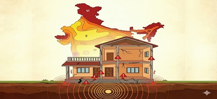
Introduction of New 'Zone VI'

  • The most significant and historic change is the creation of a new seismic zone, Zone VI.
  • Previous Status: Previously, the maximum risk in India was classified as Zone V.
  • New Status: The entire Himalayan arc—Jammu & Kashmir, Ladakh, Himachal Pradesh, Uttarakhand, and northeastern states up to Arunachal Pradesh—is now included in the new ‘super-critical’ Zone VI.
  • Reason: Scientific studies indicate that these regions experience tectonic stress much higher than expected, with a potential for earthquakes exceeding magnitude 8.0.

Expansion of Risk Area (61% of India)

  • According to the new map, 61% of India’s land area falls under moderate to high seismic risk.
  • Several cities previously considered safe or low-risk are now upgraded to high-risk zones.
  • Some adjustments were also made in southern India and the Indo-Gangetic plains.

‘Boundary Rule’ Implementation

  • A strict boundary rule has been applied for city planning and urban development.
  • Rule: Any town or city located on the border of two seismic zones will automatically be considered part of the higher-risk zone.
  • Purpose: To ensure that administrative boundaries do not compromise safety measures.

Focus on Non-Structural Elements

  • For the first time, the code mandates the safety of non-structural elements of buildings.
  • Provision: Any non-structural element (e.g., water tanks, heavy chandeliers, false ceilings, large glass facades) weighing more than 1% of the building’s total weight must be properly anchored and secured.
  • Reason: In earthquakes, even if the building structure survives, falling heavy components can cause casualties and property damage.

Design Methodology Changes (PSHA-based)

  • The previous deterministic model has been replaced with Probabilistic Seismic Hazard Assessment (PSHA).
  • This approach not only considers past earthquakes but also provides mathematical estimation of future earthquake likelihood and intensity in a specific area.
  • Engineers can now accurately estimate ground motion for designing buildings.

Impact on Construction Costs

  • Applying the new standards is expected to increase construction costs by 10-15% in Zone V and VI.
  • Stronger foundations, additional steel, and high-grade concrete will become mandatory.

Existing Buildings (Retrofitting)

  • While the code is mandatory for new constructions, it also emphasizes retrofitting for critical existing buildings such as hospitals, schools, and bridges.
  • Governments must now audit existing infrastructure based on the updated code.

Insurance and Real Estate Implications

  • Real estate projects must undergo strict verification to obtain Earthquake-Resistant Certification.
  • Insurance companies will also consider the new seismic zone map while determining premiums.

Latest Courses